Place Fell
Seasoned explorer Athena Mellor is the mind behind Ramble Guides, a website for the modern explorer who wants to make the most out of the UK’s beautiful hikes. Athena visited Another Place to put together a hiking guide for one of the many walks on our doorstep at the hotel.
PLACE FELL | IN BRIEF
START: GLENRIDDING | 11.3 KM | MODERATE HIKE
This hike begins in Glenridding, where you will take the Ullswater Steamer one stop to Howtown. From here, follow the Ullswater Way until a cafe stop at walkers-only Lowther Barn Tearoom, then leave the Ullswater Way to head into the fells. Ramble up to the summit of Place Fell with stunning moorland and valley views, then descend to the green eden of Patterdale, following the road for the last mile back to Glenridding.
Hiking around Ullswater with Athena Mellor
“I wandered lonely as a cloud”, proclaimed Wordsworth in his 1807 poem ‘Daffodils’, inspired by a ramble on the shores of lovely Ullswater, not far from his home in Grasmere. These words hung in my mind while I wondered the shores of Ullswater myself recently, while staying at Another Place, The Lake. Like Wordsworth, I found myself in a state of complete serene loneliness that gave me much pleasure while bounding between rocks on the pebbly, windswept shore, and squinting my eyes over to the distant fells to the South West that seemed so tempting from where I was. A haze of hills layered in the distance, while dark stormy clouds hung above them tentatively. I focused my gaze to the furthest point and decided that that is where I would go…
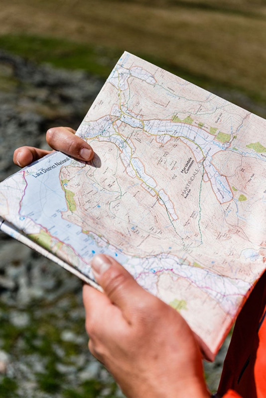
What better way to get to know the area than to ramble into the heart of it. So, during my stay at Another Place, the Lake, while sat in their lovely Living Space drinking coffee and poring over OS maps, I plotted a route onto those distant fells I could see from the water’s edge, laced up my walking boots the next day and headed for the hills.
BEGIN BY WATER
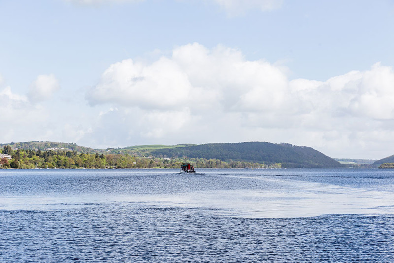
CATCH THE ULLSWATER STEAMER FROM GLENRIDDING TO HOWTOWN
Whooshing along water seemed like a unique and leisurely way to start our ramble. We heard about the Ullswater Steamer from the hotel, so instead of creating a circular walk like I normally would, I planned a linear walk with a lift to the start by boat. Simply turn left out of the hotel and drive south along the A592 until you reach Glenridding, where there is a large pay & display carpark. Head down to the pier (signposted), and purchase your ticket for the Ullswater Steamer heading to Howtown. When the boat departs, you’ll be whizzing along the water for around half an hour before you reach a lovely dock in quiet, little Howtown. The village is only accessible by car on a one-way road, so it feels like a wonderfully wild, beautiful and isolated place to start your hike.
ALONG THE LAKE
HIKE ALONG THE ULLSWATER WAY FROM HOWTOWN TO LOWTHER BARN TEAROOM
Bear right along the footpath out of Howtown and you will soon find signs for the Ullswater Way (symbolised with a daffodil), which you’ll now be following for the next two miles. The Ullswater Way is a recently established trail set up by the Lake District National Park authority, whose rangers and volunteers
have been working hard to develop, improve, maintain and promote it. The Way runs for twenty miles right around Ullswater, heading over farmland, fells, along the lake’s gentle shores and through forested woodland. While some may run or walk the Ullswater Way in just a day, other’s will attempt to complete it in sections, or over a few days. Our hike takes you along a small part of it, and is simply a taste of what the
full hike would be like.
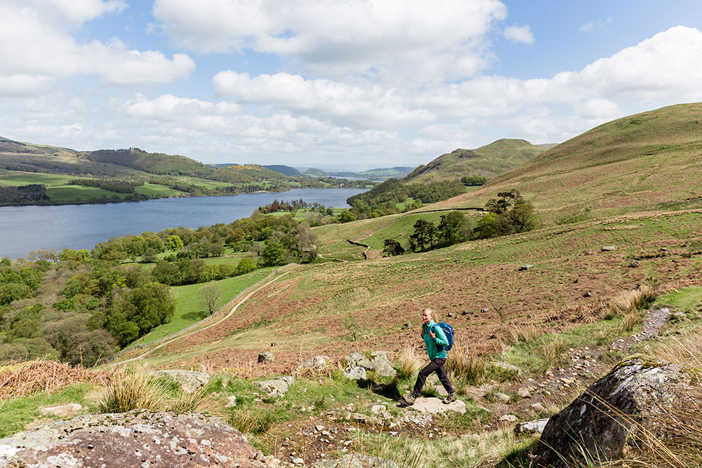
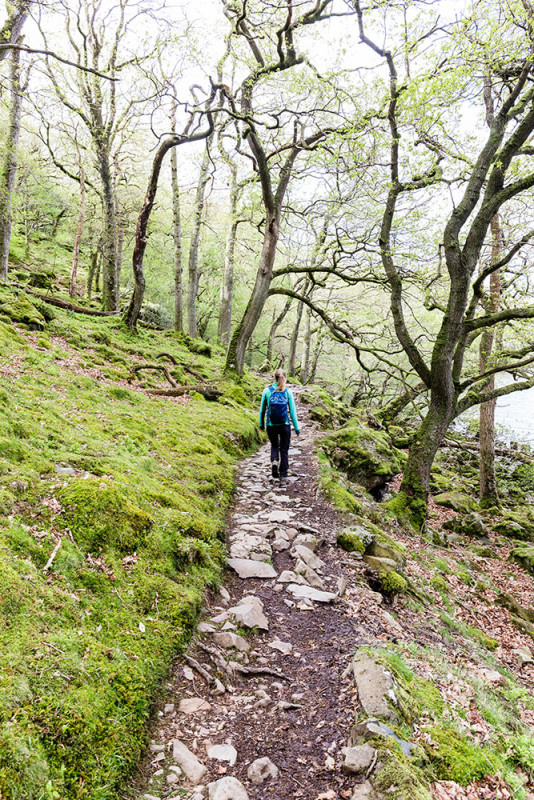
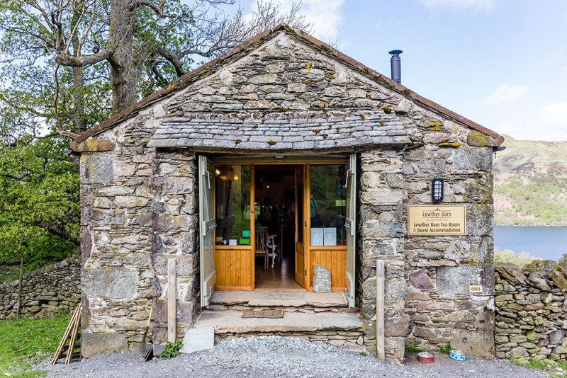
This beginning part of the trail is undeniably stunning. Ramble through gentle woodland and along rolling farmland with beautiful views of Ullswater and the surrounding hills. The Way is well-signposted and easy to follow. Pass Beckside Farm at Sandwick, with a meandering beck and stunning old oak tree beside it, then continue along the footpath until you reach Lowther Barn Tearoom, a walkers-only cafe with lovely views onto Ullswater. Here we enjoyed a cup of tea and a quick rest, picking up freshly made, hot sausage rolls that we packed away for the summit.
INTO THE FELLS
ASCEND FROM LOWTHER BARN INTO THE FELLS
So far the walk has been softly undulating and pleasant, but now you will begin ascending into the hills. From the tearoom, take the footpath left straight after the stream and follow it up until the beck appears alongside you on the right. Keep turning around on this stretch, as views behind you onto Ullswater are breathtaking, and despite the steep climb you’ll be glad to be gaining some height and heading away from the shores. Continue along the obvious footpath, keeping the beck to your right (though not always visible) as you pass a disused quarry (left) and crumbling building (right).
After the quarry, the footpath becomes a little vague and the ground can be boggy after rainfall, but head towards the low sheep-pen where a path from the left joins. Turn right so you are facing the foothills of Place Fell. At this point, views of Ullswater have disappeared beyond the hills you have just climbed up, replaced by the surrounding yellow moorland.
N.B. Before ascending, consider the weather conditions. If bad weather and low visibility, we’d recommend staying on the Ullswater Way all the way back to Glenridding. However, if the weather is fine and you’re feeling fit, start the ascent to Place Fell.

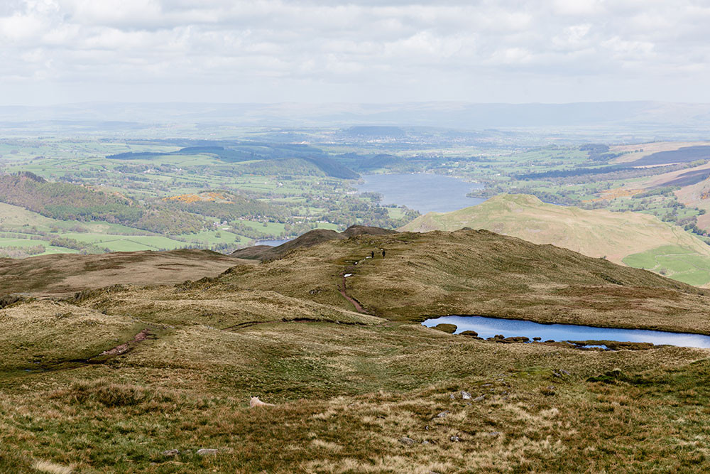
HILLTOP
THE FINAL ASCENT UP TO PLACE FELL
After turning right at the sheep-pen, you will come to a split in the footpath in around 50 metres. Here you have two choices: the left-hand path heads directly up to the summit of Place Fell, on an obvious and easy to follow track; the right-hand path is a little vaguer and longer, but views down to Ullswater are unbeatable and the moorland that opens up before you is simply breathtaking. From the right hand track, you can actually see the whole trail you’ve been following up from Ullswater, with views of rolling moorland and distant peaks; an array of textures, colours and shadows.
N.B. The rest of the route description will describe the right-hand track (the one that we took and that needs a little more explanation).
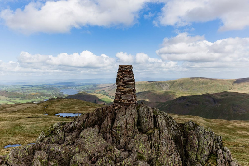
Head around the corner past Mortar Crag as Ullswater disappears behind you. At times the track seems to be lost and there is some boggy marshland to avoid, but you should soon cross a beck which you can then follow almost to the summit. The ground around the beck is quite boggy, but don’t worry if you have to venture away from it as the cairnstones for Place Fell can actually be seen looking up to the left – so as long as you keep these in sight, and the beck fairly visible, you can’t go too far wrong! Pass Hart Crag on your left (a rocky outcrop that sits below Place Fell), then at some point you should see the other path join from the left and a small tarn nestled into the hillside. Begin the final rocky ascent to the summit of Place Fell until you reach the cairnstones.
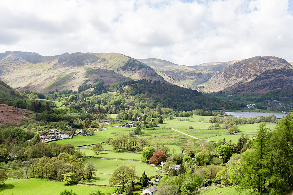
Views from the summit are fine, as Ullswater reappears into sight in the north, and the green valley of Patterdale is visible in the south. Yet the most striking view is that of the eastern flanks of the Helvellyn range, a sharp ridgeline that still showed remnants of snow in early May, when we visited, despite the warm weather for the previous few weeks. Bring a warm and windproof jacket for the summit, and find a sheltered spot to eat your lunch and take in the views.
DOWN TO THE VALLEY
DESCEND FROM PLACE FELL TO PATTERDALE, THEN ALONG THE ROAD TO GLENRIDDING
Follow the obvious path to descend, where there is a relatively tricky downward scramble before the track turns to gravel and winds down the valley. Follow it down to the beck, where the track appears to go up and numerous paths meet. To the right, there are some cairnstones which you should head towards before taking the right-hand path to continue the descent.
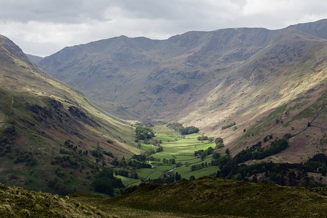
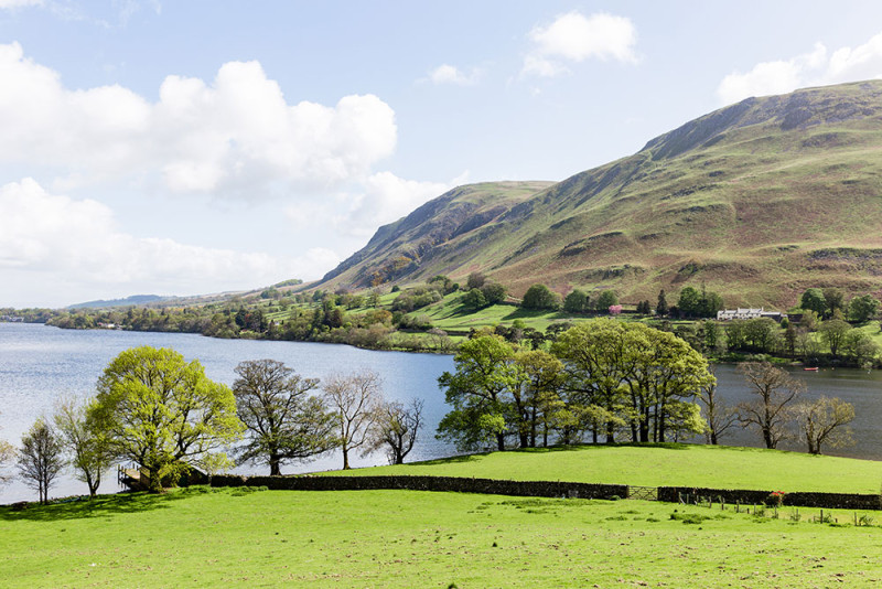
To your left, the valley of Patterdale looks like a green eden of flora and fauna, a stark contract to the barren landscape atop the fells. When you reach the bottom of the hill, head right through the gate sign-posted to the public bridleway, then left at Side Farm and follow the path past the fields until you reach the centre of Patterdale. Turn right at the road and follow the footpath for about a mile back to Glenridding.
Beginning this ramble on the water, then heading through forest, farmland and moorland to the summit of Place Fell makes it varied, interesting and challenging; so when you eat your lunch at the cairnstones you feel satisfied to have reached it. The descent is short and views down to the green fields of Patterdale are stunning. Soak your muscles in the hot tub back at Another Place when you return, and enjoy a tasty dinner that will be both well-deserved and much-appreciated.
Walking in the Lake District comes with risk and conditions change quickly. We would always recommend checking the weather forecast, wearing suitable clothes and choosing a walk for your ability. We would also recommend taking an OS map and compass and know how to use them. The hotel takes no responsibility for any injury, loss or damages that may occur when following the directions.